






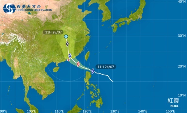
The Hong Kong Observatory said tropical cyclone Noul will enter within 800 kilometres of HK by around Friday evening (July 24), and will issue the No. 1 Standby Signal at 8:40 p.m. tonight.
HK will remain extremely hot during the day on Saturday (July 25), but swells are expected over the waters. Members of the public are advised to stay away from the shoreline and suspend all water activities.
As Noul strengthens and moves closer to the eastern coast of Guangdong, local winds will gradually strengthen later on Saturday, with more squally showers expected. The Observatory will consider issuing a higher tropical cyclone warning signal on Saturday afternoon, depending on changes in Noul's intensity, the distance between its strong wind areas and HK, as well as local wind conditions.
According to the current assessment, Noul is more likely to make landfall in the area between Huizhou and Jieyang in the early hours of Sunday (July 26), although its distance from HK remains uncertain.
Affected by Noul, HK will experience strong winds, squally heavy showers and thunderstorms on Sunday, with rough seas and large waves. Members of the public are advised to monitor the Observatory's latest weather updates.
Related News:
HK braces for potential tropical storm Noul as forecasters track developing system



Comment