


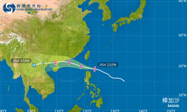
Super Typhoon Ragasa is expected to cross the Luzon Strait and enter the northern South China Sea today (Sept. 22). With its expansive circulation and rapid movement, Ragasa poses a significant threat to the Guangdong coast. The Hong Kong Observatory will issue a No. 1 standby signal at 12:20 pm today.
The Observatory stated that as Ragasa gradually approaches, wind conditions in Hong Kong will intensify tomorrow (Sept. 23), with a rapid deterioration in weather expected later. The Observatory is considering issuing a No. 3 strong wind signal between 8 pm and 10 pm tonight. It is anticipated that Hong Kong will experience strong winds to gale force on Wednesday (Sept. 24), with offshore and highland areas potentially reaching hurricane strength. Severe weather is expected, including strong winds, heavy rain, and thunderstorms, with very large waves and surging tides at sea. Due to significant storm surges, coastal water levels could be similar to those during Typhoon Hato in 2017 and Typhoon Mangkhut in 2018. Citizens are advised to make all necessary preparations for wind and flooding as soon as possible and to closely monitor the latest weather updates from the Observatory.
Related News:
Super Typhoon Ragasa: Deteriorating weather in HK Tuesday, gale to storm winds expected Wednesday


Comment