


The Hong Kong Observatory (HKO) announced today (March 4) that temperatures in the city will gradually drop in the coming days due to the influence of a northeast monsoon and an associated extensive cloud band. The latter part of the week will see significantly cooler weather, with urban areas expected to experience a minimum temperature of around 13°C on Friday (March 7). In parts of the New Territories, temperatures could fall as low as 11°C to 12°C.
A rebound in temperatures is forecast for early next week, as an easterly airstream replaces the monsoon, bringing sunnier skies starting Monday (March 10).
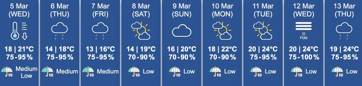
The Observatory reported that today's temperatures in HK ranged from a minimum of 20°C to a maximum of 27°C. The weather was generally cloudy with a few showers, patches of fog along coastal areas in the morning, and occasional thunderstorms in the afternoon. Periods of sunshine were observed during the day. With a cold front expected to move across coastal areas tonight, temperatures will begin to drop tomorrow, with a minimum of 18°C, which is 9°C lower than today's maximum. Cooler weather will persist over the following days, with Friday morning being especially chilly.
According to the Observatory's 9-day weather forecast, temperatures will gradually rise over the weekend and into early next week. However, a humid maritime airstream is expected to affect coastal areas by midweek, with humidity levels reaching up to 100%. Residents are advised to stay updated on the latest weather information, dress appropriately for the changing conditions, and take precautions to stay warm.
Related News:
Humidity concerns in HK: Effective home moisture prevention tips revealed


Comment