


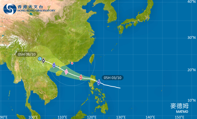
The Hong Kong Observatory has stated that the tropical cyclone Matmo will cross Luzon today (Oct. 3) and later enter a range of 800 kilometers from Hong Kong. The Observatory is considering issuing a No. 1 standby signal tonight.
According to the Central Meteorological Observatory, this morning, Typhoon Matmo has intensified to a strong tropical storm level. As of 5 am, its center was located about 290 kilometers northeast of Manila, Philippines, over the ocean, with maximum winds near the center reaching level 10 (25 meters per second). It is expected that Matmo will continue to move in a northwesterly direction, making landfall along the eastern coast of Luzon Island in the Philippines and crossing the northern part of Luzon. By the afternoon to evening, it will move into the eastern waters of the South China Sea and gradually approach the western Guangdong coast and eastern Hainan Island, with increasing intensity, potentially reaching strong typhoon level (14-15, 42-48 meters per second).
Meteorological experts remind that Typhoon Matmo will enter the South China Sea, bringing significant winds and rain to the central and northern parts of the South China Sea and southern Guangdong from the night of Oct. 3 to Oct. 7. Vessels at sea should return to port in a timely manner to avoid the storm, and the public should take preventive measures against typhoons in advance and closely monitor the latest forecasts and warnings issued by meteorological authorities.
Related News:
HKO may issue Standby Signal No. 1 tonight, higher warning possible tomorrow


Comment