


The Hong Kong Observatory (HKO) issued a forecast on Oct. 1, predicting that tropical cyclone "Matmo" will strengthen into a typhoon as it moves closer to HK. By the evening of Oct. 3, Matmo is expected to enter the region within 800 kilometers southeast of HK, with further intensification likely as it approaches.
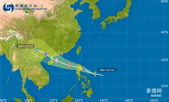
According to the Central Meteorological Observatory, Typhoon Matmo formed at 8:00 a.m. on Oct. 2 in the northwest Pacific Ocean, approximately 680 kilometers east of Manila, Philippines. The maximum wind speed near its center reached 8 on the Beaufort scale (18 m/s). The typhoon is currently moving west-northwest at a speed of about 20 kilometers per hour, with its intensity steadily increasing.
Chief meteorological analyst Xin Xin said that due to favorable conditions such as high sea surface temperatures and weak vertical wind shear, the tropical depression is expected to strengthen further. Although it may weaken slightly as it passes over the Philippines, it is projected to regain strength in the South China Sea, reaching typhoon intensity. Current forecasts suggest that Matmo is highly likely to make landfall on Oct. 5, either in Hainan or the Leizhou Peninsula in western Guangdong.
Xin also noted that the typhoon's path is clear due to a strong and stable subtropical ridge to its north, making it one of the most predictable typhoons of the year. Its trajectory is expected to be remarkably straight, minimizing uncertainty in its movement.
Related News:
Tropical storm Matmo likely to approach HK within 800 kilometers on Friday evening


Comment