


The Hong Kong Observatory (HKO) announced today (July 16) that the local weather this afternoon and tonight will be generally cloudy with scattered showers and thunderstorms. Brief sunny intervals in the afternoon will make the weather hot.
Moderate to fresh east to southeast winds are expected, with strong winds occasionally blowing in high areas initially.
The outlook for the next one or two days includes occasional showers and thunderstorms.
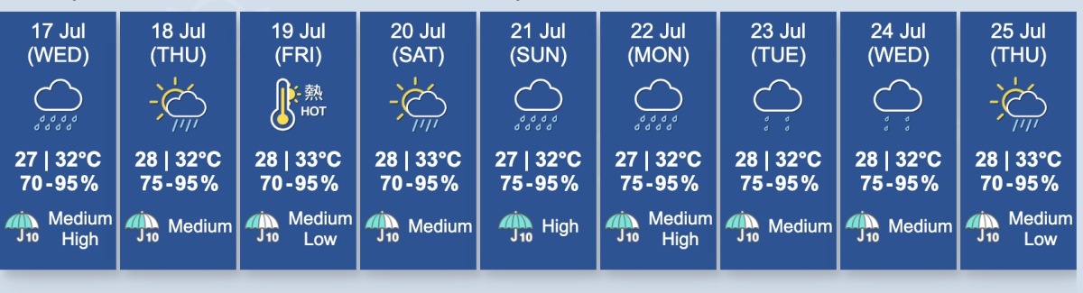
Friday will be extremely hot. The weather will become increasingly unstable from the weekend to early next week, with severe storms and thunderstorms expected.
According to the nine-day weather forecast, on DSE (Diploma of Secondary Education) result release day tomorrow (July 17), there will be thunderstorms in some areas, with heavy rain at times initially.
There will be brief sunny intervals by the weekend, but some areas will have severe thunderstorms and heavy rain later in the day.
Winds will initially remain moderate to fresh east to southeast, with strong winds occasionally blowing in high areas later.
HKO stated that the broad low-pressure trough over the South China Sea will affect the coastal areas of Guangdong, bringing showers and thunderstorms over the next one or two days.
With the strengthening of the subtropical ridge, southeastern China will experience scorching weather later this week.
The low-pressure area located east of the Philippines is expected to cross the Philippines in the next few days, enter the South China Sea, and potentially develop further.
During the weekend, the weather along the coast of South China and the northern part of the South China Sea will be unstable. However, the development and path of this low-pressure area remain uncertain.


Comment